
We can scan your mountain bike trail in 3D
Simple equipment, exceptional results. We scan on foot with a small camera, which likely costs less than a drone or LiDAR survey and still gives you a true-to-scale 3D model. You don't need to do anything except tell us where to scan. No permit headaches.
Ask about your trail- 3
- parks scanned
- 8
- trails scanned
- 10.9
- kilometres scanned
The problem
Tourism
Riders don't know if the trails will be right for them. They might see some photos or videos but these only show them so much.
A true-to-scale model in their web browser lets them explore before they travel.
Races
Racers who can't get to the course early are left guessing from someone else's head-cam footage, which hides how steep and how big things are.
A scan gives every rider the same course preview, with real distances and gradients.
Building and regulatory
Showing a land manager or other stakeholders a new build, or an issue on a trail, is hard from photos. Photos don't show scale or gradient, and not everyone can walk the trail.
A scan is a record of the trail as it stands that anyone can look around and measure.
What you get
- A true-to-scale 3D model of the trail that opens in any browser. No app and no signup.
- A link for each trail that you can share anywhere.
- The measured length of the trail, and how much of it is uphill, downhill and flat.
- Tools in the viewer: a ruler to measure between two points, objects of known size to drop in for scale, and sun and shadows for different times of day.
- Extra analysis on request, such as gradients, feature sizes and slope along the trail, delivered as a short report.
- A viewer you can embed on your own website, or a link to ours.
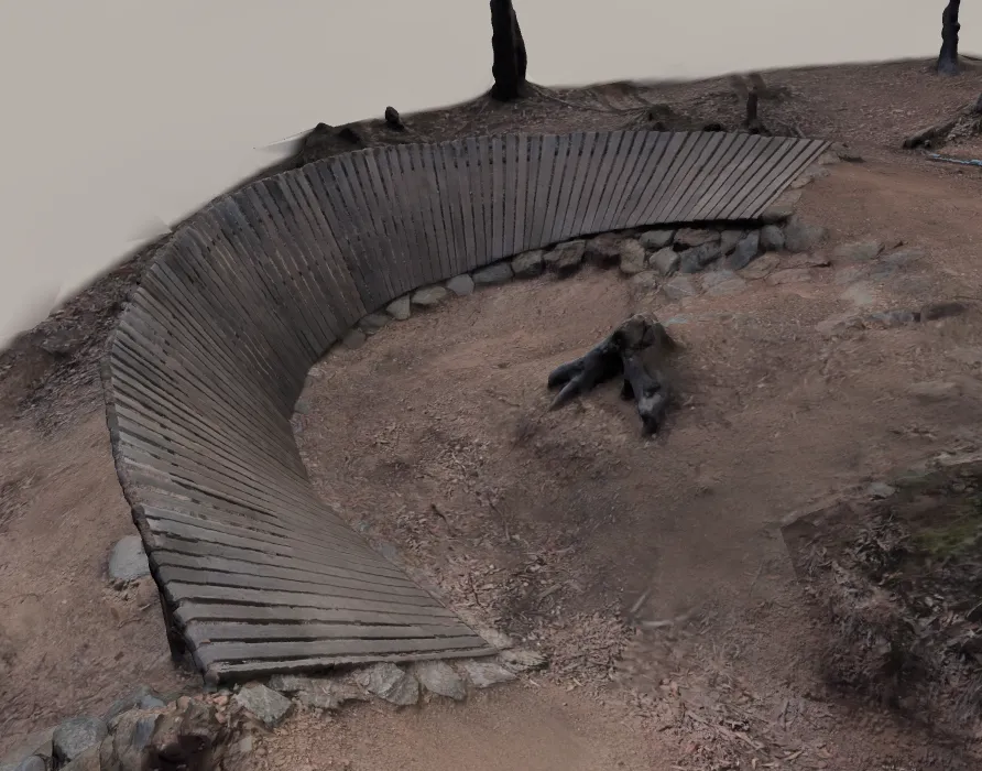 An example of the resultPipeline at Gap Creek Reserve
How it works
- 1
Tell us about the trail
Fill in the form below. Say where it is and what the scan is for.
- 2
We discuss your goals
What do you want to use this for, so we can tailor the output.
- 3
We visit and scan it
About one hour per kilometre, on foot. The trail can stay open.
- 4
We process the scan
Most trails can be processed overnight.
- 5
It's published
We send you the link. Anyone can explore the trail in 3D.
Questions
- What does it cost?
- Priced by quote, based on trail length and what you need from the scan. Because we scan on foot with simple equipment, it likely costs less than a drone or LiDAR survey. Tell us about your trail and we'll send a quote.
- How long will you be on site?
- About one hour per kilometre of trail.
- Does the trail need to close?
- No. We scan on foot with a small camera and no drones, so there's little risk to riders using the trail. We can work with you to complete risk assessment as required.
- How long until the scan is published?
- Most trails can be processed overnight.
- Who owns the model?
- By default you can use and share the model however you like, and we publish it on DirtScan. If you need different terms, such as keeping it private, we can agree that before we scan.
- How accurate is it?
- Features are within 10 cm of their true size, and the whole trail is within 0.5 m of its true length. We are not a professional surveying service. Scans are for information only and should not be relied on for engineering, construction, legal or safety decisions.
- Where do you travel?
- Anywhere. We're in Brisbane and mostly scan Australian trails, but trails from anywhere are welcome.
- What conditions do you need?
- Any day it isn't raining.
Tell us about your trail
Where it is, how long it is, and what you want the scan for. We'll reply with a quote.
Or email us directly at contact@dirtscan.app.
The method and the code we use are open source. If you'd rather scan a trail yourself, there's a DIY guide.